The RV Journal Interfacing the iPAQ with the Navaid Autopilot
|
 |
|||
(This page has numerous updates because the iPAQ installation was a process of evolution over a period of several months during the early development of the AnywhereMap system.. Matter of fact, the old iPAQ 3765 was eventually replaced with a Dell x30. Obviously this means much of the material presented is out-dated, but hopefully a careful reading will still be useful in gathering ideas for installing the iPAQ with Anywhere Map software) Part One It seems that a very satisfactory configuration of the Anywhere Map system is now in place in my RV-6. The
main objectives were to achieve an installation with minimal loose cables and with a solid
interface with the Navaid autopilot. The first iteration included the Sentinel compact
flash card GPS; very quickly I realized the external antenna was going to be necessary to
get the performance of the Sentinel up to acceptable level, even under the full canopy of
the RV-6. Without the external antenna, GPS lock was occasionally lost in turns and climbs
(the RV-6 is capable of climbing with impressive deck angles), but the least satisfactory
aspect was the poor altitude readouts that often were hundreds of feet in error. The
external antenna greatly helped the altitude performance and GPS lock reliability, but now
there was another cable dangling from the panel.
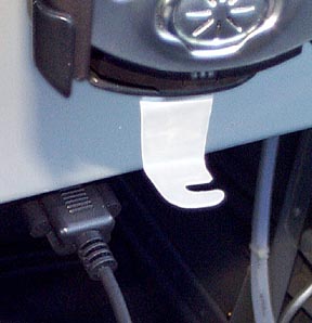
Update: Here are photos of the keeper I devised to prevent the serial cable from dropping out of the iPAQ connector.
A small piece of scrap 0.016" 6061 aluminum was cut, trimmed, and bent into the configuration shown. It was then attached to the bottom of the expansion sleeve with a single pop rivet. The slot is sized to fit snuggly around the cable just below the connector.
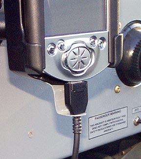
Here is the cable securely attached to the iPAQ. Some sort of arrangement such as this is necessary because the retention hardware on the cable connector is very small and flimsy. The cable is inserted into the slotted clip, and the iPAQ is slid into the expansion sleeve. I removed some material from the top of the RAM cradle so the iPAQ could be inserted into the top of the sleeve without removing it from the cradle.
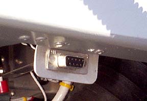
A DB-9 plug was wired with pins 2 and 3 jumpered; when this plug is inserted into the panel connector, the data feed is routed from the Lowrance to the Navaid in the original configuration.
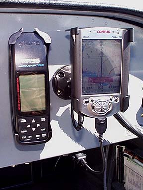
The mount used for the iPAQ is from RAM. The cradle is RAM-HOL-CO1, and the ball/socket mount is RAM-SB-190. These are available from gpscity.com.
A serial cable was procured for the iPAQ 3765 (Compaq part number
236251-B21). When the plug is replaced with the serial plug on the iPAQ cable, NMEA data
transmitted by the Lowrance goes to the iPAQ, and data returned by the iPAQ/AWM goes to
the Navaid. The iPAQ then is able to find its location courtesy of the fine receiver in
the Lowrance, and the Navaid gets the benefit of the cool navigation features of the
Anywhere Map. The Navaid appears to be perfectly happy with the data it receives from the
AWM and the Smart Coupler functions just as it does when coupled to the Lowrance. (right-click on the graphic below to download a larger version for printing)
(note: if the iPAQ is not powered by the plane's power bus, it may be necessary to add a ground connection on pin 5)
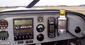
There is a minimum of extraneous cabling in the cabin; the serial cable is
only a few inches long and goes directly to the DB-9 panel connector, and the power cable
for the iPAQ runs inconspicuously to a power outlet beneath the panel. The RAM mount with
iPAQ cradle is mounted beside the Lowrance in easy reach and eyesight, and a fat,
easy-to-grip homemade wood stylus is velcroed to the side of the cradle. The Anywhere Map software on the iPAQ computer is not yet a perfect combination, but the features present now are just a preview of the exciting options that no doubt will be forthcoming. Even with the Approach phase of the software in early development, the Anywhere/iPAQ combo is an impressive addition to the RV panel; if the pilot already owns an iPAQ and suitable GPS receiver, the Anywhere Map has to be one of the best navigational bargains available.
Update on flying the Anywhere Map interface with the Navaid After flying with the Anywhere Map/Navaid combination, I have noticed a couple of issues with this combination. The first inkling I had that the AWM was steering the Navaid differently than the Lowrance Airmap was when I noticed the RV-6 "snaking" gently as it proceeded along the route. I have become accustomed to seeing the Lowrance signal hold the Navaid to within three or four hundredths(!) of a mile of course centerline with heading corrections so minute they are nearly imperceptible. It appears that the AWM has a course deviation resolution of no better than one tenth of a mile either side of centerline. This results in the plane scalloping along the course as it corrects in 2/10th's mile increments. While this is not a serious issue, after being spoiled to the near perfect tracking performance of the Lowrance, it is disappointing to have the plane gently turning back and forth as the Navaid is guided by the much less precise CDI of the AWM. I have also seen the CDI in AWM suddenly make a minor change as the map redraws when zoomed in or out; this results in a heading correction being transmitted to the Navaid.
Update to the Update (4/17/05) The Navaid was replaced by the vastly more capable EZ-Pilot from Trio Avionics. Unfortunately, as of AWM version 1.6.2, standard NMEA data protocol is not provided by AWM and it is unable to drive the EZ-Pilot. Users of the Navaid can still use AWM since the Navaid only needs course correction data.
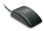
Update; Installation of Garmin GPS35-HVS receiver The previous shortcomings of the AWM software for driving the Navaid prompted me to install a Garmin GPS35 receiver that is dedicated solely to the iPAQ. This enabled me to move the Navaid duties back to the Lowrance Airmap 100 which does a stellar job of driving the autopilot.
The GPS35 is a self-contained twelve channel GPS receiver and antenna. I purchased the HVS version from gpscity.com that can be used with an input of 6-40vdc, and comes with a 15' cable with bare wire ends. The unit is about the size of a computer mouse, and is the similar to the GPS35 sold by Control Vision in their AWM bundles. The bare wire version worked fine for me since I already had the interconnections for the iPAQ in place. The red and black wires were attached to 12v and ground respectively, and the white wire went to the data input pin on the DB9 connector I had previously installed for the iPAQ serial cable. The receiver was attached to the glare shield with double-sided tape unobtrusively beside the Lowrance antenna. I have found the GPS35 to be a fine receiver which achieves satellite lock almost immediately. It was already configured for 4800 baud serial output so no further configuration was necessary. Now the Lowrance driving the Naviad and the GPS35 driving the iPAQ are independent and provide a great cross-check on each other.
Part Two (Here is a copy of a post I sent to our local group, The Tennessee Valley RV Builders Group, on my initial impressions of the Anywhere map) I now have a few hours flying with the Anywhere Ipag-based moving map
software, enough to begin forming some opinions. The mount is by RAM and the cradle is
designed just for the iPAQ.
Here is the iPAQ with the Sentinel flash card GPS receiver mounted in the compact flash sleeve. The external antenna is not shown.
Sam Buchanan
Return to The RV Journal front page
Please submit all questions and comments to sbuc@hiwaay.net
|
Getting Ready to Build Building the Tail Building the Wings The Finish Kit
|
|