Home       
Cycling       
Graphics       


Guntersville Parks and Mountains 76

        This ride is 76 miles, exploring the parks and mountains northeast of Guntersville. The route is flat to rolling with three climbs and a few long hills, traveling on mostly good pavement over varied terrain.

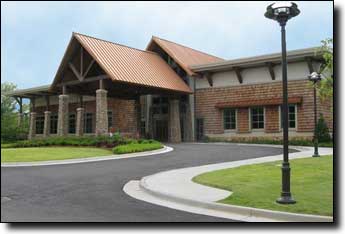
The ride starts at the lodge in the Lake Guntersville State Park. Having recently completed a $25 million renovation, this is a very nice start point and the Pinecrest dining room offers a breakfast buffet Saturday and Sunday mornings from 7:00 to 10:00 am for $6, menu only on weekdays.

There are 54 mile and 63 mile versions of this ride, and an alternate start point in downtown Guntersville (closer to Huntsville but adds about ten miles to the ride).

Guntersville Lake state park lodge
        This route begins with a descent to a counter-clockwise tour of Lake Guntersville state park, then travels north along the lake and through farmland to the first climb at mile 20, up Sand Mountain at Langston Gap (topo), gaining 600' in 1.4 miles for an average grade of 8%. This is a pleasant tree-covered climb on a quiet road.

The route then turns south for a few miles of rougher pavement, dropping down into the Buck's Pocket State Park at mile 27 for a rest stop at the picnic area (restrooms with water and coke machine but no food). Just before the park the road can be under water if there have been recent heavy rains, though it's usually passable on a bike.

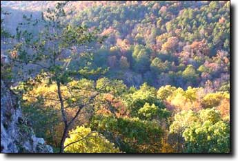
The climb out of the park (topo) is short, only a half mile, but gains 270' for an average grade of 10% with a few very steep sections. There's an optional hilly out-and-back side trip to an overlook with a picnic area but no water, left at the top of the climb 0.5 miles, then left for another mile.
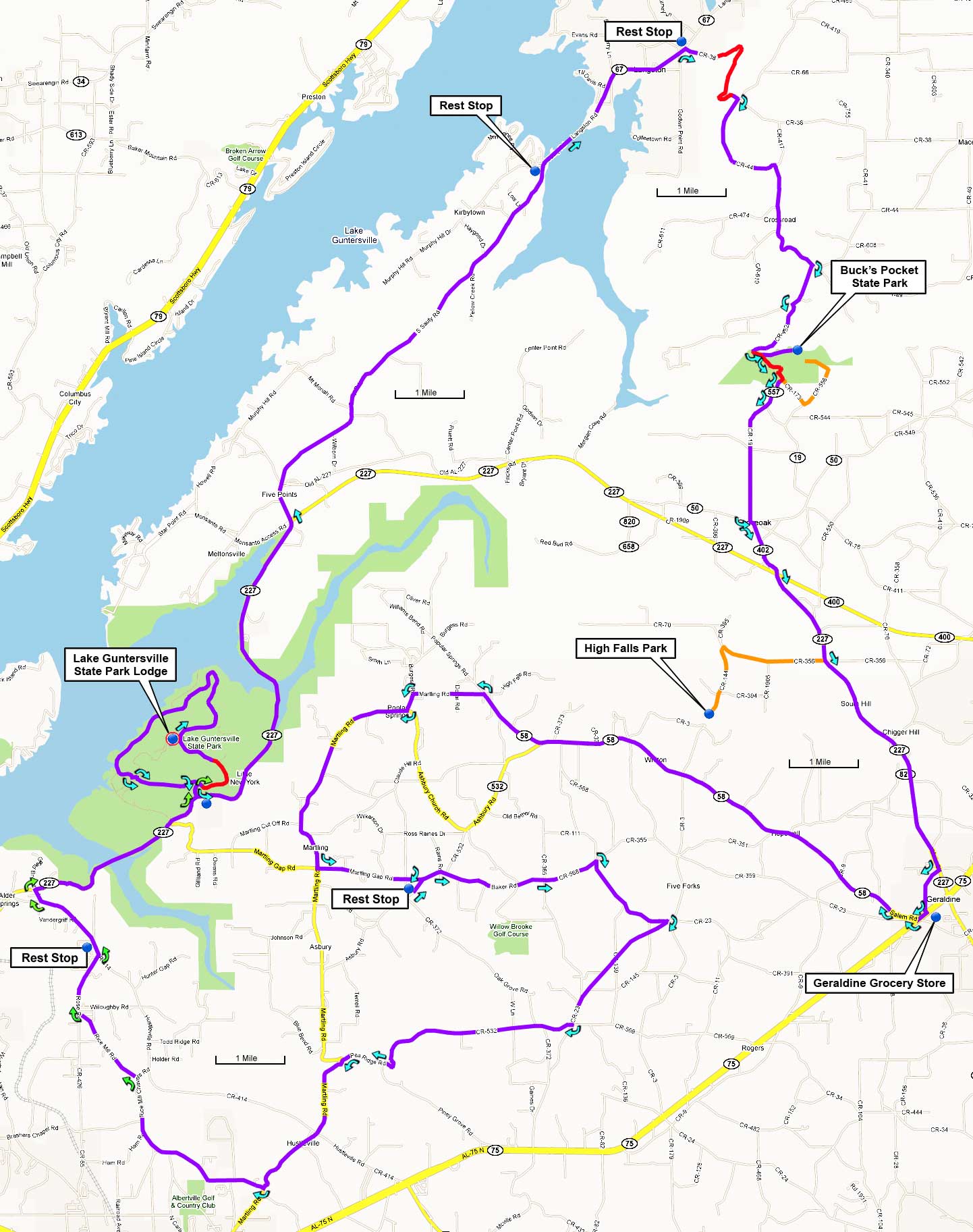
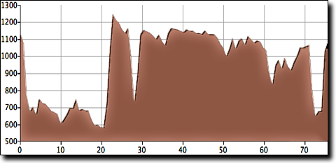
At mile 33 there's an optional side trip to High Falls, a wide waterfall with a bridge and swimming area. This out-and-back side trip adds five miles total on some rough roads, including a short steep road down to the falls which may be uncomfortable in cleated shoes. While there are restrooms and coke machines the facilities are spartan and the water has a strong mineral taste.

Guntersville Parks and Mountains map
       

The ride continues through quiet and varied farmland, on generally good roads, with a few small 100' to 200' gorge climbs. The route finishes with a descent down off Sand Mountain along a wonderful winding road leading back to the Lake Guntersville state park and the final climb (topo) back up to the lodge, which gains 300' in 0.7 miles for a moderate average grade of 8%.

Buck's Pocket state park
        Directions to start:

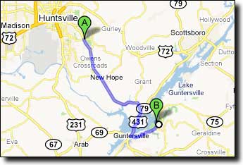
This ride begins and ends at the lodge in Lake Guntersville State Park, about a 50-minute drive from the Sutton Road intersection near Hampton Cove (Walmart/Publix). From that intersection:

Travel south on US-431 29 miles into downtown Guntersville. Turn left at AL-227/Lusk Street and travel 7.1 miles. Turn left into the Lake Guntersville State Park, turn right on Aubrey Carr Scenic Drive just inside the park and travel uphill 1.6 miles past a golf course to the Lodge on your left on Lodge Drive:

Google Maps driving directions to:

The Lodge in Lake Guntersville State Park
1155 Lodge Drive
Guntersville, AL 35976

Directions to Lake Guntersville
       
Printable cue sheet Route map Google Earth file:
KmzGuntersville76.kmz

Miles Turn  Description Leg
0.0 Left  on Lodge Drive 0.1
0.1 Left  on Aubrey Carr Scenic Drive
4.0
4.1 Left-Right  at Lodge Drive to stay on
 Aubrey Carr Scenic Drive
1.0
5.1 Right  to exit the park 0.2
5.3 Left  on AL-227 5.2
10.5 Straight  across Monsanto Road onto
 S Sauty Road / CR-582
6.8
17.3 Rest Stop  at convenience store / restaurant -
17.3 Continue  northeast across the causeway,
 S Sauty Road becomes Langston Road / CR-67
2.8
20.1 Rest Stop  at convenience store on left -
20.1 Right  on Langston Gap Road / CR-38
 (road hidden past sign)
0.5
20.6 Begin climb  606' in 1.4 miles, 8% average grade 1.5
22.1 Right  on CR-44 3.4
25.5 Right  on CR-152 0.6
26.1 Left  on CR-452 (steep descent) 1.0
27.1 Continue  CR-452 becomes CR-173 crossing creek 0.2
27.3 Left  on CR-174 0.3
27.6 Rest Stop  at Buck's Pocket state park picnic area
 (restrooms and coke machine only)
-
27.6 Return  west on CR-174 0.3
27.9 Left  on CR-173 and begin climb:
 268' in 0.5 miles, 10% average grade
0.5
28.4 Right  on CR-557 0.5
28.9 Right  on CR-19 1.8
30.7 Left-Right  across CR-50 onto CR-402 0.8
31.5 Straight  onto AL-227 1.5
33.0 Straight  (or optional side trip to High Falls,
 follow signs, adds five miles to total)
3.6
36.6 Right  on Pine Street 0.7
37.3 Rest Stop  at grocery store in Geraldine -
37.3 Southwest  on AL-75 (left from grocery store) 0.1
37.4 Right  on Salem Road 0.4
37.8 Right  at "T" onto CR-58 (no sign) 7.2
45.0 Left  on Martling Road / CR-409 1.0
46.0 Left  to stay on Martling Road 0.3
46.3 Right  to stay on Martling Road 3.3
49.6 Left  on Martling Gap Road 1.6
51.2 Sharp Right  on Asbury Road 0.1
51.3 Rest Stop  Asbury Grocery on right, across from school -
51.3 Northeast  on Asbury Road 0.1
51.4 Slight Right  on Baker Road 2.6
54.0 Continue  Baker Road becomes Dalrymple Cemetery Road 0.8
54.8 Sharp Right  on CR-11 / CR-111 1.5
56.3 Right  on CR-23 2.1
58.4 Right  on CR-569 (small road) 0.4
58.8 Bear Right  on Pea Ridge Road 2.8
61.6 Bear Right  to stay on Pea Ridge Road 0.6
62.2 Left  on Martling Road (short climb) 2.3
64.5 Right  on Rice Mill Chavers Road
 just after bridge
2.8
67.3 Left  on Rice Mill Road 1.3
68.6 Right  on Rose Road / CR-65 at "T" 0.9
69.5 Slight Left  on Hustleville Road 0.1
69.6 Rest Stop  at convenience store on left -
69.6 North  on Hustleville Road 1.1
70.7 Right  on Gerald Bryant Road 0.2
70.9 Right  on AL-227 3.0
73.9 Left  to enter Lake Guntersville State Park 0.2
74.1 Right  on Aubrey Carr Scenic Drive 0.1
74.2 Begin climb  300' in 0.7 miles, 8% average grade 1.5
75.7 Left   on Lodge Drive 0.1
75.8 Finish  at the Lodge -