Home       
Cycling       
Graphics       
 

Union Hill Metric

        The Union Hill metric is 63 miles, starting and ending at the Union Hill school, which is located on Brindley Mountain just south of the Tennessee River. The route is mostly flat-to-rolling with two long climbs near the end. It travels on good pavement thru beautiful quiet farmland and there are three rest stops fairly well placed on the course. There's also a store across the street from the start location school. This is a very rural area and motorists are noticeably friendly toward cyclists.

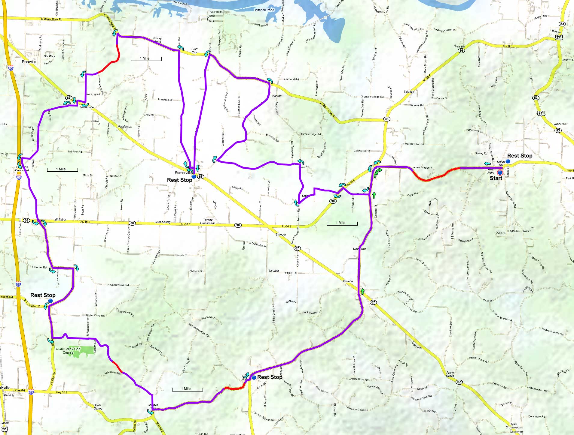
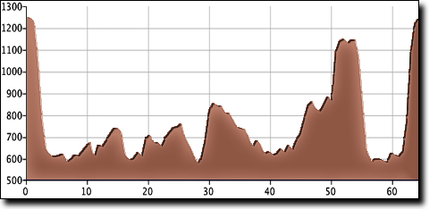
In addition to the two main climbs there are two steep hills that gain close to 200 feet. Most of the climbs come later in the route so ride the first half conservatively to finish strong.

The Union Hill short version cuts out the final climb and some mileage in the middle for an easier 48 mile distance.

Thanks to Jeannie Mackay for mapping this route out, she has several more Huntsville area rides on her website.

Union Hill metric loop map
        Directions to start:

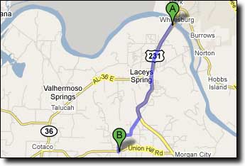
This ride begins and ends at the Union Hill School. Travel South from Huntsville on HWY-231 (Memorial Parkway) across the Tennessee River. Begin counting mileage after crossing the bridge and drive 5.7 miles...

Miles Turn Description Leg
5.7 Right on Apple Grove Road 1.1
6.8 Bear Right to stay on Apple Grove Road 1.4
8.2 Arrive Union Hill School -

Google Maps driving directions to Union Hill school.

Directions to Union Hill school
       
Printable cue sheet Route map Google Earth file:
KmzUnion.zip

Miles Turn  Description Leg
0.0 West  on Union Hill Road 4.4
1.6 Descend  Brindley Mountain -
4.4 Left-Left  at AL-36 onto Cotaco Florette Road 0.9
5.3 Right  on Red Oak Road 0.9
6.2 Left  on AL-36 0.2
6.4 Right  on Herman Bailey Road 1.6
8.0 Right  on Antioch Road (main road, no sign) 1.3
9.3 Left  on Nelson Hollow Road 2.8
12.1 Right  on Center Springs Road 3.4
15.5 Left  on E Upper River Road 2.2
17.7 Left  on Bluff City Road 3.8
21.5 Rest Stop  at AL-67 in Somerville -
21.5 North  on Bluff City Road, backtracking 0.1
21.6 Left  on Broad Street 0.1
21.7 Right  on Cain Road 3.9
25.6 Left  on E Upper River Road 2.1
27.7 Left  on Thompson Road NE 2.1
29.8 Left  on Peach Orchard Road 1.0
30.8 Right  on East Old Somerville Road 0.2
31.0 Staight  across onto Horse Center Road 0.3
31.3 Left  on Shoal Creek Road 2.8
34.1 Left  on Bethel Road 0.2
34.3 Left  on Lockhart Road 2.0
36.3 Left-Right  across AL-36 onto Peachtree Road 1.6
37.9 Left  on E Parker Road 0.7
38.6 Right  on Mt Tabor Road 1.6
40.2 Rest Stop  at Cedar Cove Grocery -
40.2 Left  on Mt Zion Road 1.0
41.2 Left  on Nat Key Road 4.8
46.0 Left  on Gandy Cove Road 3.5
48.6 Climb  Brindley Mountain ~ 260' -
49.5 Rest Stop  at convenience store -
49.5 Left  on Eva Road 5.2
52.6 Descend  Brindley Mountain -
54.7 Straight  across onto Cotaco Florette Road 4.1
58.8 Right-Right  at AL-36 onto Union Hill Road 4.4
60.5 Climb  Brindley Mountain ~ 590' -
63.2 Finish  at Union Hill School on Apple Grove Road -