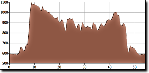
The route is fairly hilly with three climbs. The first starts at mile 22 and is the toughest with two steep sections, the other two climbs are fairly easy. There's a Jet Pep convenience store where the route crosses AL-157 at 25 miles; another small store is on CR-1101 around mile 30 but it may be closed. The covered bridge rest stop at 50 miles has restrooms, water and a soda machine. There are some stores four to seven miles after the bridge, near West Point; traffic picks up in this area but it's only heavy during school/work drive times.
Note: a bridge on Gandy Cove Road is currently under construction. It can be walked around on a dirt path but may not be passable after a rain.
|
|
|||
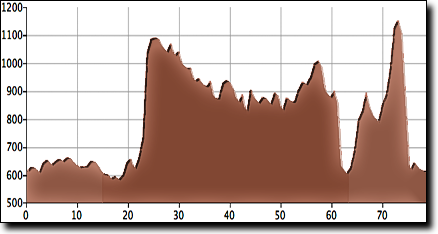
The total elevation gain is 2,180', starting at 620' with a maximum elevation of 1,150'. The darker section shows the 48 miles that this route overlaps with the 54 mile version.
The start for this ride is 15.7 miles after crossing the Tennessee River, at the intersection of AL-36 and AL-67, a few miles past the Cotaco ride start. Park at the Hickory Stick BBQ or small office building next door; 6 Mile Road is accessible from the parking lot.
Google Maps directions to the start. From Madison it's much faster to take I-65 south to AL-67.
Scenic Covered Bridge Ride
The 54 mile version of this ride starts at the high school in Falkville which is located a mile west of
The 54 mile route includes only one climb from the 78 mile route, and while it's a tough climb with two steep sections it comes at mile 7 while riders are fresh. The Jet Pep convenience store where the route crosses AL-157 is early at 10 miles; another small store is located on CR-1101 at mile 15 but it may be closed. The covered bridge rest stop at 35 miles has restrooms and water and a soda machine, there's a store 4 miles after the bridge.
|
|
|||
The total elevation gain is 1,400', starting at 600' with a maximum elevation of 1,090'.