This route has not been ridden yet so for now there are no cue sheets or maps, only Google Maps directions.
Directions to start:
If traveling over Monte Sano on US-431 (east on Governors Drive): go 4.8 miles after passing Monte Sano Boulevard and turn Left at Old 431/Sutton Road. If traveling over Cecil Ashburn Drive: continue straight on Sutton Road for 0.7 miles and go straight across US-431.
Begin counting mileage at the intersection near the Publix shopping center...
After 1.6 miles: Right onto Old 431 (Cove Park ballfields at right)
After 1.3 miles: Left onto Cherry Tree Road
After 2.2 miles: Left onto McMullen Road
After 1.0 miles: Left onto Candlestand Circle
After 0.4 miles: House on left, 136 Candlestand Circle
| Day | Miles | Start | End | Climbs |
| 1 | 89 | Huntsville | Monteagle | 2 |
| 2 | 89 | Monteagle | DeSoto State Park | 2 |
| 3 | 72 | DeSoto State Park | Lake Guntersville | 2 |
| 4 | 69 | Lake Guntersville | Huntsville | 0 |
Two climbs. Lunch in Cowan or Sewanee, dinner at Pappa Ron's (Italian) in Monteagle. Stay at the American Eagle Inn in Monteagle.
Route Details:
The route winds it's way to and through Gurley onto the US-72 shoulder for 2 miles. US-72 is a high traffic road but the shoulder is wide traveling east. Turning north on AL-65 is one of the best cycling roads in the county, along the scenic and usually quiet Paint Rock valley. There are few rest stops on this road so stop at the store in Hollytree, 11.5 miles after turning onto AL-65, to stock up.
The road travels into Tennessee and skirts Huntland, which has stores but is a mile off-route to the northwest. The route then turns east through very rural farm country with some rough pavement and hills, working it's way to Cowan where there are stores. After Cowan the ride takes US-41, a somewhat busy main road with a shoulder, and climbs up to Sewanee, there's an extra lane on part of this climb which is not steep.
Sewanee is a good location for lunch, check the Stevenson-Sewanee Ride for more details. After Sewanee the road turns north and descends into a quiet farming valley. You'll climb back up out of the valley into Monteagle, finishing just after the top of the climb.
|
|
|||
Two climbs and lots of hills. Lunch in Trenton. Cloudland Canyon State Park stop, six miles after Trenton, adds a few miles. Motel and dinner at DeSoto State Park.
Route Details:
US-41 from Monteagle to Midway road is a busy road, with a rumble strip shoulder, so not the best, but only 2.3 miles. After turning from Midway Road to Jump Off Road (quiet road with lots of hills) Google shows lots of turns but there really aren't any turns all the way to South Pittsburg where the road bears left to become 2nd Street. The bridge over the Tennessee River is low traffic and has a wide shoulder, watch for a wide expansion joint though.
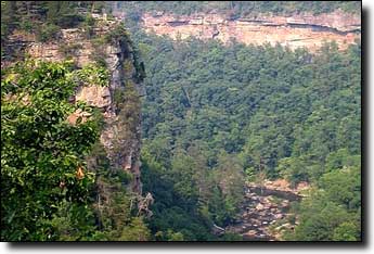
Climb Sand Mountain on CR-93, the Chattanooga's 3-State 3-Mountain century ride has used this climb. The route crosses Sand Mountain, descending down into Trenton, be sure to get food and water as there are few rest stops later. After Trenton the road climbs up Lookout Mountain on AL-136, there's an optional out-and-back stop at the Cloudland Canyon State Park which adds a few miles.
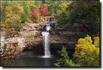
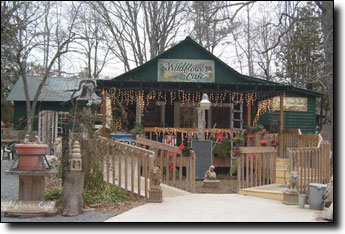
Right turn onto AL-157 where there's a store at that intersection but AL-157 is along a ridge and hilly with no stores. Flarity Road and CR-631 take to you Mentone, a little traffic on AL-117 but only a couple of miles. In Menton there's the Wildflower Cafe, a nice restaurant on AL-117 (off the road to the left so easy to miss) and a convenience store on the right, before turning onto CR-89. CR-89 is a beautiful road along a ridge with some nice homes (optional out-and-back side trip to DeSoto Falls along this road adds a couple of miles) winding down to the DeSoto park and Lodge.
|
|
|||
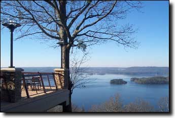
Two climbs and hilly. Lunch? Hotel and dinner at the Lake Guntersville State Park Lodge. Save 4 miles by not circling DeSoto State Park at the start.
Route Details:
Starting from the DeSoto park, the route loops back though the park, 4 miles and some hills that can be skipped. The route then heads south on sometimes rough roads to the Little River Canyon, a fantastic cycling road, curvy with small hills, great pavement. After exiting the Little River Canyon the route turns west to Dogtown where there's a store as the road becomes CR-81. The road descends off Lookout Mountain and turn left onto US-11.
US-11 is a straight road with some traffic, usually not bad. Cross and parallel I-59 and climb Sand Mountain on CR-52. This road leads you to Geraldine, there are stores and a grocery store on AL-75, just to the right near Salem Road.
Use the Guntersville Parks and Mountains 54 cue sheet from Geraldine at Mile 37.3 on that cue sheet to the Lake Guntersville State Park Lodge at the end. The cue sheet is more accurate than Google Maps, many roads in that area do not have road signs so it can be difficult to follow Google Maps directions. The ride finishes with climb up inside the park to the Lodge.
|
|
|||
No climbs. Lunch in Scottsboro? Save 3 miles by not circling Lake Guntersville State Park at the start, shorten by a few more by taking AL-35 instead of CR-30 to Woodville.
Route Details:
Starting in the park, the route descends and loops around for lake and mountain views. North on AL-227 is very nice and scenic along the lake followed by S Sauty Road through rolling farm country. Across the causeway at a trailer park where there's a store, and then several more miles before turning left onto AL-35, a 4 lane divided highway with some traffic. The bridge across the Tennessee River into Scottsboro on AL-35/Veterans Drive has some traffic but there's a shoulder. Turning west the route takes some backroads through Scottsboro to avoid traffic on AL-35 through downtown, the turns may be confusing but basically they just parallel AL-35.
After Scottsboro onto CR-30 the route quickly returns to rural farm country, with some rough pavement, not bad, but there are many miles of rough so it can get old. An alternate route, staying on
|
|
|||