Home       
Cycling       
Graphics       


Salem Backroads Century

        The Salem Backroads Century is 100 miles, starting from the Athens State University Library parking lot on the North side of Pryor Street in Athens. Traveling along quiet and isolated country back roads, the ride includes a few miles on rough pavement (mostly on Puncheon Branch Road). The route is mostly rolling with a few short steep hills. While not mountainous, the total elevation gain is 4,000 feet.

Thanks to Jeannie Mackay for mapping this route out, she has several more Huntsville area rides on her website.

Salem backroads century map
        Directions to start:

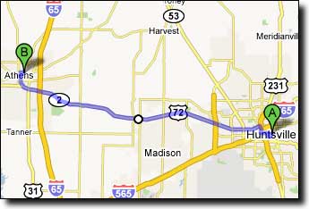
This ride begins and ends at the Athens State University Library at 407 East Pryor Street in Athens, Alabama. From Huntsville, take Highway 72 West to Athens (about 15 miles from Huntsville). Turn right on South Clinton Street and travel North about a mile, turn right on Pryor Street. The library is about 0.2 mile on the left, parking just past the library.

Google Maps driving directions to Athens State University Library.

Directions to Athens State University Library
       
Printable cue sheet Route map

Miles Turn  Description Leg
0.0 West  on Pryor Street 1.0
1.0 Right  on Hine Street 5.1
1.9 Continue  on Edgewood Road -
6.1 Left  on Fort Hampton Road 6.7
8.0 Continue  on Elk River Mill Road -
12.8 Right  on Cairo Hollow Road 2.4
15.2 Right  on Cottonbelt Road 3.2
18.4 Bear Left  on Salem Road 1.4
19.8 Left  on AL-99 0.1
19.9 Rest Stop  on right (next stop 9.8 miles) -
19.9 Right  on Salem Minor Hill Road 9.3
29.2 Right  on TN-11 0.5
29.7 Rest Stop  on left (next stop 23 miles) -
29.7 Left  on Puncheon Branch Road (rough pavement) 8.6
33.7 Continue  on Peach Road -
36.9 Continue  on Shannon Road -
38.3 Straight  on Pleasant Ridge Road 4.7
43.0 Left  at "T" on Shores Road (no sign) 0.1
43.1 Right  on Mayfield Road 0.5
43.6 Left  on Fall River Road 9.1
52.7 Rest Stop  at 4-way intersection (next stop 20.9 miles) -
52.7 Right  on Old Florence Pulaski Road 4.8
55.5 Continue  on Old Florence Pulaski Hwy -
55.9 Continue  on Hurricane Creek Road -
57.5 Right  on Lee Chapman Road 0.5
58.0 Bear Right  to continue on Lee Chapman Road 1.0
59.0 Left  at "T" on Johnson Branch Road (no sign) 0.6
59.6 Right  on White Road 1.6
61.2 Left  on Fall River Road 4.5
65.7 Right-Left  across TN-11 onto Oak Grove Road 3.2
68.9 Right  on Charles Davis Road 0.6
69.5 Left  on J Black Road (sign around corner) 3.6
73.1 Right  on TN-11 0.5
73.6 Rest Stop  on right (26.5 miles to finish) -
73.6 Left  on Powell Road 1.2
74.8 Left  on Jackson Hollow Road 1.4
76.2 Left  at "T" on Puncheon Branch Road 0.2
76.4 Right  on TN-11 0.5
76.9 Left  on Salem Road 8.4
81.2 Continue  on Salem Minor Hill Road -
85.3 Left  on Easter Ferry Road 13.8
94.0 Continue  on Edgewood Road -
98.2 Continue  on Hine Street -
99.1 Left  on Pryor Street 1.0
100.1 Finish  at Athens State University Library -