Shortcut options:
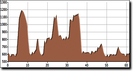
This route lends itself to shortcutting, with three options. Skipping all three would result in a 44 mile ride (44 mile cue sheet).
The first shortcut comes at mile 4.2, skipping 3 miles and the long climb up West Point Road. Shown in orange on the map, simply continue onto Pines Church Road for 2.1 miles, then turn left onto Pines Road for 1.9 miles. Return to the metric cue sheet at "Mile 11.2" for the turn onto Forman Bottoms Road.
The second shortcut skips the 9.8 mile loop between the first and second rest stops (the same store). Once you reach the first rest stop, simply follow the metric cue sheet from the 2nd rest stop at "Mile 34.3" for this option, which also skips a climb.
The third shortcut skips the 5 mile loop at the north end of the route. At mile 48.0 on the metric cue sheet, turn right on E Upper River Road (instead of left). Go 0.3 miles and turn right again, onto Antioch Road for 4.2 miles, then continue at "Mile 53.1" on the metric cue sheet.

| Metric cue sheet | 44 cue sheet | Route map |
| Metric RideWithGPS | 44 RideWithGPS |
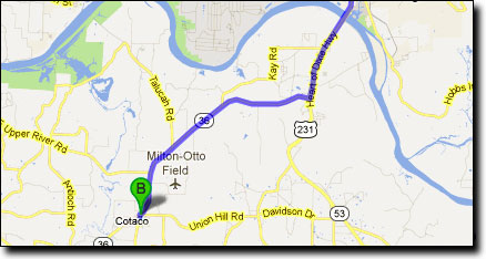
Legend has it that Cotaco was the name of a Creek Indian chief in the area. The original pronunciation was Cuh-tauk-uh but the locals now pronounce it Co-TAY-co, with all long vowel sounds.

This ride begins at the Cotaco School parking lot, on Cotaco School Road off of AL-36, south of the Tennessee River. Travel South from Huntsville on