Major Features

Specifications

General Description

Disclaimer

GoogleEarth Viewer Program

GoogleHunt Plotter Program

KML Output Files

Install / Operation

More GoogleHunt Information
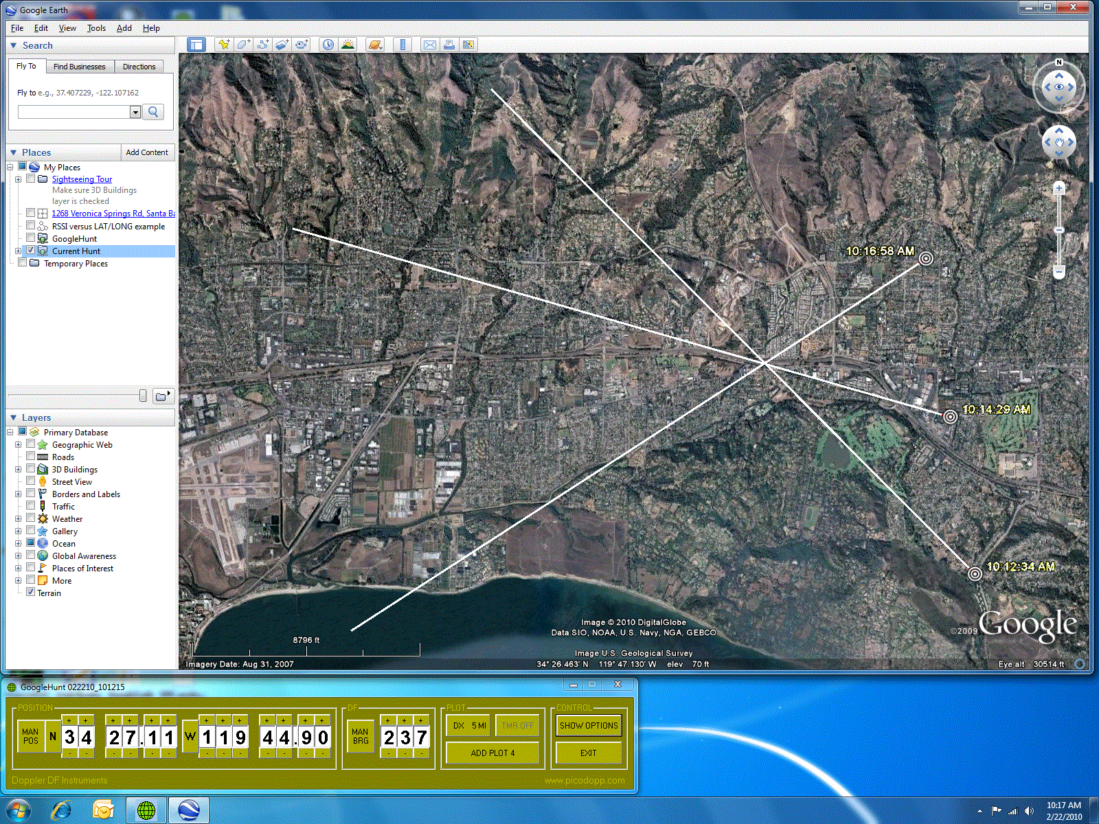
Typical Display : GoogleHunt with GoogleEarth
More GoogleHunt Information
Major Features |
Typical Display : GoogleHunt with GoogleEarth
|
Major Features :
Specifications :

GoogleHunt Runs on any Windows operating system

GoogleEarth runs on Win2000, XP, Vista and Win7 systems

Display refresh  : 4 seconds delay, minimum ( user defined, usually = 10 seconds )

Selectable manual / automatic data input for lat/long and DF bearings

Automatic data input : RS232 COM port, user selected COM1 through COM8

GPS / DF COM port data remains valid for 10 seconds ( unless replaced by newer data )

An open internet link is not required for mobile operation

		( see GoogleEarth Viewer Program section, below, for details )
General Description :
The GoogleHunt DF plotting program is a Windows program that accepts manual and/or automatic inputs of DF latitude, longitude and bearing data, and displays the results on a GoogleEarth ( satellite image ) viewer screen. This provides a “map display” of multiple DF bearing lines, to facilitate mobile hunting of radio signals.
Individual plots are “triggered” by the DF hunter and displayed a few seconds later on the GoogleEarth viewer screen. Up to 100 plots can be recorded in a single GoogleHunt session, and multiple sessions ( spanning hours, days or weeks ) can be displayed simultaneously.
Automatic lat / long data must come from a ( user-provided ) GPS receiver that generates RS232 NMEA GPRMC sentences. Automatic DF data must consist of RS232 Agrello format DF messages. A PicoDopp DF ( with user-provided GPS receiver ) provides all the information required to drive GoogleHunt.
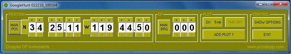
Manual data entry is performed using “buttons” on the GoogleHunt control panel. This allows GoogleHunt to be used with non-computerized DF equipment, such as a chart and a Yagi. It also allows users to “simulate” a hunt at home, ( for instruction / learning purposes ) by manually entering various values of lat / long and DF bearings. Manual data input also permits plotting of DF information provided ( by any means available ) from remote locations. ( EXAMPLE : verbal reports from other hunters, working together as a team )
Disclaimer
The GoogleEarth viewer program is a ( free / public ) product of Google Corporation of Palo Alto, California, USA.
The GoogleHunt DF Plotting program is a ( free / public ) product of Doppler DF Instruments, Santa Barbara California, USA.
There is NO ASSOCIATION OR COLLABORATION between Google Corporation and Doppler DF Instruments, regarding these two programs. The name chosen for the GoogleHunt plotting program derives EXCLUSIVELY and ONLY from the fact that the ( free / public ) GoogleEarth Viewer program is employed to provide a display for the GoogleHunt plot results. Therefore, please direct ANY and ALL questions / comments to Doppler DF Instruments, NOT to Google Corporation.
GoogleHunt was created by Bob Simmons ( WB6EYV ) using VisualBasic 6 on a PC running a Windows 7 operating system, in December 2009.
GoogleEarth Viewer Program
The GoogleEarth viewer program is a ( free / public ) satellite image display program, created and provided by Google Corporation, Palo Alto, California. It can be downloaded through the internet and installed in a few minutes.
An internet link is also required to retrieve the satellite images provided by Google Corporation, for display on the viewer. A complete set of detailed satellite images for the entire planet would require far too much computer memory ( in the user’s computer ) to make GoogleEarth practical, so images for specific areas are retrieved ( when requested ) through the internet link.
This implies that an open internet link is required to use GoogleEarth, ( and therefore GoogleHunt also ) but experiments by GoogleHunt users has revealed that GoogleEarth automatically stores “copies” of the ( requested ) satellite images on the hard drive of the user’s computer. ( cache memory storage )
This is probably done to accelerate the operating speed of the GoogleEarth viewer, but it also means GoogleEarth ( and therefore GoogleHunt ) can be used without an internet link, if the area being hunted has been previously “scanned” by the hunter. ( to build up a “local library” of satellite images, for later viewing )
Mobile operation of GoogleHunt ( when an internet link probably will not be available ) therefore is practical, and GoogleHunt users have reported successful mobile operation, with no open internet link, after previously scanning the hunt area using GoogleEarth. ( to build a library of satellite images for mobile operation )
GoogleHunt Plotter Program
The main features of the GoogleHunt plotting program are described in the GENERAL DESCRIPTION section. ( see above, this page ) Secondary features are described in this section, and specific details about ALL features can be found in the “GoogleHunt_Instructions” document, available for download as a .doc file in the INSTALL / OPERATION section, below.
Vector Length : The length of each GoogleHunt “vector” is user-defined with a control panel button. Available values range from zero vector length to 100 miles. Different plots can have different vector lengths. Once a plot has been generated, there is no way to change the vector length, for that plot.
Plot Timer : GoogleHunt has a “timer” function that allows plots to be automatically generated at regular time intervals, when enabled. This feature can only be enabled if a GPS is used for a lat/long source, and plots will only be generated if the GPS speed is 3 knots or greater. If no valid DF data is available at the scheduled time for a plot, ( signal = not present ) the location will be plotted, but with a vector length of zero. ( no bearing line )
This ( timer ) feature has limited value in most hunts, but it can be useful for “solo” hunters if they are hunting a steady signal. ( like a stuck mike PTT button ) In this case, enabling the timer and simply “driving around” for a while will cause multiple DF plots to be accumulated automatically, so that the driver does not need to compromise road safety by simultaneously operating the DF equipment.
Com Port Select : On the OPTIONS page, the user may select one of 8 possible COM ports for automatic data input. Only a single port is used for data input from both the GPS and the DF. ( PicoDopp DF units “merge together” DF and GPS data into a single stream )
If a different combination of DF and GPS units is employed, GoogleHunt operation is still possible, if the port is manually switched back and forth between the DF and GPS units… In GoogleHunt, data remains valid for 10 seconds.
Com ports are automatically “tested” when selected, to ensure they are free and available for use by GoogleHunt. The result of these tests are displayed on the caption of the button used to select the port. ( button caption = “free” or “busy” )
Color Scheme : The user may also define the various colors on the OPTIONS page, as well as the color employed for the DF vector ( plot ) lines.
Configuration Data : As a convenience for the user, many of the parameters in GoogleHunt are automatically saved when it shuts down, and retrieved when it starts up. This includes the last values selected / displayed for lat / long and the COM port, and color scheme information.
Output Files : GoogleHunt actually generates two identical KML output files, one for archive purposes and one for viewing with GoogleEarth. The file for GoogleEarth viewing has a constant filename that never changes, so that GoogleEarth only needs to be configured once, to display it. The contents of this file is cleared every time GoogleHunt starts up, ( number of plots = zero ) and it is updated whenever a plot is triggered by the user.
The second output file is an archive file, with a unique filename that actually expresses the date and time of the file’s creation. For example filename “022010_214840.kml” was created on February 20, 2010, at local time 9:48:40 p.m. These files are created each time GoogleHunt starts up, and each has a unique filename, to ensure data from each hunt is available for later viewing, if desired.
These files are located in a GoogleHunt folder, located on the C: drive of the host computer. This folder is automatically created when GoogleHunt is installed.
KML Output Files
In order to “link together” the GoogleHunt Plotting program and the GoogleEarth Viewer program, information is passed from GoogleHunt to GoogleEarth using KML files. These are very similar to HTML files, and can be viewed with a text editor, if desired.( open WordPad and view them as “plain text files” )
KML actually stands for “Keyhole Markup Language”. KML was developed originally by KeyHole Corporation of Mountain View, California, USA, with collaboration and support from Google Corporation. KML is now an open international language standard, very similar to HTML, but optimized strongly for the display of visual information on geographical maps and satellite images. The term “Keyhole” is actually a reference to a series of surveillance ( spy ) satellites used by the United States, ( KH series ) during the “cold war” era.
During normal operation, the GoogleHunt program updates a KML output file each time the user “triggers” a new plot. The output file is placed at a specific location on the host computer’s hard drive, and it overwrites any earlier versions of the same file. To display the file’s contents, the GoogleEarth viewer program is instructed to automatically examine this file at regular time intervals, ( typically every 10 seconds or so ) and use the file contents to “refresh” the GoogleEarth display.
Install / Operation Instructions
GoogleHunt is provided as a "zip" file, on this website. This is done to prevent download problems due to firewalls and anti-virus programs that might ( otherwise ) block the download. ( a download link is provided below ) To install and use GoogleHunt, the file must first be "unzipped" using a ( free ) copy of the ( very popular ) WinZip utility program, available here :
GoogleHunt can be downloaded from the PicoDopp main page, ( 6.0 Mb file size ) but as a convenience for the reader, it can also be downloaded using the link provided below : ( right-click and select SAVE TARGET AS )
Once the GoogleHunt zip file has been downloaded, create a new file folder on the desktop, ( temporary, name = not important ) and place the GoogleHunt zip file into it. Then use the WinZip utility program to "unzip" it, ( unpack the contents ) and place all the unzipped files into the same folder.
One of the ( unzipped ) files will be "README_INSTALL.txt". Open this file ( double-click it ) and follow the instructions to install GoogleHunt
( NOTE : GoogleHunt uses an installation "wizard" program called 'setup.exe' that automates the installation process... double-click it to start it )
Instructions about the use of GoogleHunt are included in the installation process. The installation will add GoogleHunt to the START/PROGRAMS menu, along with a copy of the instructions. ( also installed in the START/PROGRAMS menu ) If the reader wishes to see these instructions, ( without installing GoogleHunt ) a separate copy can be downloaded using the link below :
Because GoogleHunt has provisions for manual input of lat/long and DF data, users can install and run it without any DF equipment and / or without a GPS receiver. This is useful for instruction / education purposes, or to evaluate its features. ( HINT : the reader can download, install and run it IMMEDIATELY, if desired )
More GoogleHunt Information
More information ( if desired ) about the GoogleHunt program can be obtained by contacting me ( Bob Simmons ) via e-mail at this address :