page two |
|
|||
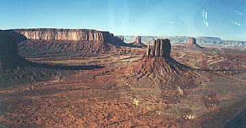
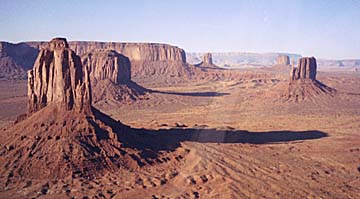
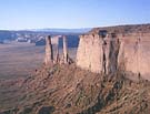
Monday morning dawned bright and crisp as we loaded the planes with bags and precious fuel on the ramp at Page, AZ. The rock formations visible to the east of the field were previews of the incredible flight we were about to undertake. The next 2.1 hrs would take us east from Page to Monument Valley, through the valley, southwest back toward Flagstaff, and on to the mind-blowing landing at Sedona. On the way to Monument Valley, we climbed to 10,500 feet as we recoiled from the vast and hostile terrain below our little homemade airplanes. This was the highest altitude us flatlanders had ever attained in our RV's. The Lycomings continued their contented purring as I nervously lead the gaggle of rednecks over spectacular canyons and boulders toward Monument Valley. In less than a half hour, the distinctive rock formations of the Valley appeared and we started a descent to, well, ........tourist altitude.
As we blasted over Goulding's Lodge just west of the valley, we formed up in single file for some truly flight simulator-type flying. Soon we were carving large arcs over the towering spires and buttes of Monument Valley with the camcorders running full bore. This was the most impressive scenery I had ever witnessed from an aircraft. Even though I had previously enjoyed the area from road level, seeing the rock formations passing by the wingtips at over 135 mph was jaw-dropping. During our debriefing later over lunch in Sedona, Dave Stafford stated that our flight through Monument Valley had to be many pilot's fantasy flight.
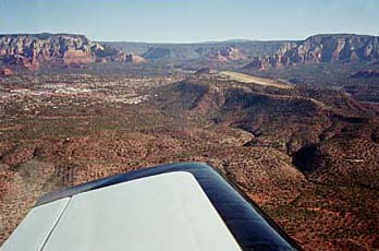
Of course we maintained the proper altitude for touring this area, but if our RV's had descended to low levels, no doubt it would have been a remarkable experience for its occupants. If one was to fly low through the area, one would no doubt be able to log one of the most unique flights available anywhere. I can only imagine what it would be like to fly at low levels through the valley..........remind me to hide that video tape...... But this remarkable morning still held great rewards. After leaving the Monuments, we continued southwest back down the mountain valleys over little towns in the middle of nowhere with names like Kayenta and Tuba City. Yes, there were airports in the isolated hamlets! The highway unerringly directed us back toward towering Mt. Humphreys, revisiting Sunset Crater. A climb to 9,500' lofted us over dense forest and soon we saw the colorful valley in which rests the charming city of Sedona. But pilots don't come to Sedona just for the artsy stuff going on in downtown Sedona. We came to land on the "USS Sedona", arguably one of the most unique airports in the nation!
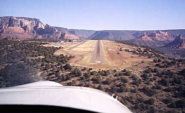
I had been trying for weeks to explain to my traveling cohorts just what awaited us at Sedona, but my descriptions of the area were insufficient to fully prepare them for their first glimpse of that itty bitty runway stuck up there on top of the mountain.
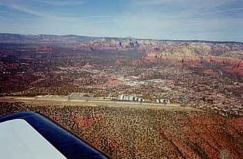
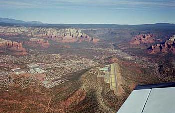
The runway is only at an elevation of 4827', but it is hundreds of feet above all the surrounding terrain. In addition, the runway has a considerable slope, so unless winds are quite strong, all landings are uphill, and takeoffs are downhill. The ATIS at Sedona was very thorough at providing the pertinent info and we came tumbling down from 9,500' to cross the airport and enter downwind for runway 03. This was one place where the VASI came in handy because for this Alabama hick, all the normal visual cues were out of kilter. We just don't routinely land on uphill runways that are a couple thousand feet above town bounded by hundred mile visibility.
Bob Butler insisted his landing was further complicated by a roadrunner that allegedly crossed the runway in front of him just as he was getting ready to flare. This creative excuse for a bumpy landing resulted in considerable discussion at lunch in the airport restaurant on various symptoms of hypoxia that could affect the visual acuity and perception, possibly even induce hallucination, of a flat-lander arriving for the first time at Sedona. Bob was vindicated later, however, as he videotaped a roadrunner scampering down the ramp near the planes.
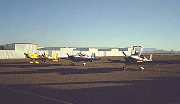
Following an intense conference at lunch concerning what direction we should wander upon leaving Sedona, we decided to skip refueling so we could depart light and head for a gas stop at Payson. We basically had to climb out of a hole once we left Sedona, so I decided to circle over the airport to gain altitude and go sightseeing before we blasted out over the vast forests that were between Sedona and Payson. I must admit this was the most adrenaline-charged launch for me of the entire trip since it became readily apparent that any engine hiccups left you no place to go except back to the runway! The 150 hp Lyc groaned and grumbled its way up and up as we circled over Sedona, savoring the wonderful colors and geology of the valley. If you ever get within a few hours of central Arizona, you really must include a stop at Sedona. I hope you are fortunate to enjoy it on a sparkling clear and mild day such as we had, and no doubt it will be a treasured entry in your logbook. This area of the state is remarkable in its variety and stunning beauty; I shall return. Our midday pow wow had resulted in plans to fly down to Tucson so we could visit the boneyard at the Air Force base. We had originally hoped to visit Deer Valley airport north of Phoenix since we had heard it is a hotbed of RV activity. However, our nightly perusals of the Weather Channel informed us of the possibility of weather blocking us out of Alabama if we dawdled too long in Arizona. Consequently the decision was reluctantly made to bypass Deer Valley and begin our eastward turn back home. Payson is another really neat airport in the high Arizona backcountry. We didn't stay long since we had just spent some quality downtime in Sedona, but we did notice there were several restaurant patrons that watched us bounding down the runway as we arrived at yet another mile high runway.
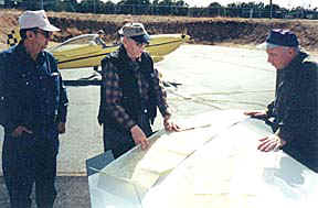
Bob, Bob, and Dave are shown trying to figure out what those blue hatched boxes on the chart signify. Every time we flew through one, there always seemed like there were a lot of A-10s and F-16s in the area.......and they seemed to waggle their wings a lot.........
After fourteen flight hours we had our first mechanical glitch. (Actually, I had been watching the bottom left cowl hinge on 399SB the entire trip because I found a broken hinge eyelet just before we left DCU. Even though the hinge remained tight for the trip, half the eyes were broken on the cowl side of the hinge by the time we returned home. I have since replaced the bottom hinges with 0.062" stock and screws.) Robin noticed a "rattle" coming from the firewall area on his RV-8 shortly after we departed Payson. By the time we reached the Phoenix area, he was irritated sufficiently by the racket to divert short of Tucson to check things out. He punched in Eloy and we headed for the flatlands. Turns out that Eloy, AZ is the parachute jumping capitol of the world! We heard quite a bit of activity on unicom as we approached, and sure enough, two big turbo-prop Otters were flying non-stop hops with over a dozen jumpers each trip. After landing, Robin found his towbar stowed against the aft wall of the forward baggage compartment and assumed that was the source of the noise. Turns out it wasn't the source (further inspection led us to believe he has a small clearance problem between a portion of the baffle and cowl). After watching the jumpers for awhile and soaking up the 80 degree sunshine, we pressed on to Tucson. We had no idea which FBO to hit at TUS, so we threw a dart at the Tucson AOPA listing and settled on Sun West Aviation. Even though it appears Sun West does not cater to transients, they treated up exceptionally well and called the Baymont Inn to come pick us up (get us out of their way?). The rational for landing at the big airport was it's proximity to the Pima Air and Space Museum and the aircraft boneyard at the Air Force base. But after examining the forecasts from the Weather Channel that evening, we decided to pull the top cowls off the planes Tuesday morning for a look see, then beat the developing weather back to Alabama. Over another gut-buster of a steak dinner that evening (as the trip progressed, we not only pressed beyond gross weight, but just became gross...) we exchanged renditions of how we had carved through the monoliths of Monument Valley, beaten the Sedona landing into submission, and advanced the art of flying to unseen levels. We all agreed that the day's 3.7 flight hours had been an incredible experience that had made the entire Arizona trip worthwhile.
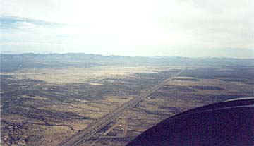
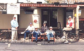
The firewall forward inspections on Tuesday morning revealed that nothing had fallen off the engines, so we pressed on to the east. The wide open expanses of the southern Arizona desert lay before us with little sign of civilization, so we decided to fly IFR over I-10 since it was going our way anyhow. For me the flight to El Paso was the most relaxed leg of the trip due to the calm air, the fantastic desert vistas, and the friendly interstate extending beyond the cowl to the east. At one point one of our party called on 122.75 to "check out the biplanes on the other side of the highway headed west". Four big bipes, all painted alike with red tails flew by in a loose gaggle. Just as I suspected, we learned that the Red Baron airshow team had left West Texas airport a short time before we arrived on their way west. Las Cruces, NM came into view on our left as the mountains of Mexico slid by on our right. We threaded our way between the restricted area of White Sands and El Paso class "C", and descended to West Texas Airport. After a relaxing 2.2 hours of flying from Tucson, we plonked down on the simple runway and taxied up to the FBO at TX04, and we were in Texas.
West Texas is the kind of airport where you could spend some quality time "just hangin' out". The place was populated by pilots of various generations, some of which could relate to Robin's dad and his recollections of P-51's and HellCats. Anything spoken on the ramp needed to be carefully parsed since it was evident the locals had amassed serious expertise at spinning dubious yarns. They seemed to genuinely enjoy our visit as we raided the candy bar and drink boxes that were maintained via the honor system. When one of our party explained that he was having trouble contributing the proper combination of coins to the coffee can that secured the FBO's funds, he was told "don't worry.....it usually works out about right". This is a place I could spend quality time out under the FBO canopy enjoying lazy afternoons in a reclining lawn chair.
Compared to the trip thus far, the remainder of our journey was rather unremarkable. We crossed the Rockies about sixty miles east of El Paso at Guadeloupe Pass where dozens of windmills were churning out electrons in the constant wind, and flew northeast to Big Spring, TX for a fuel stop. After watching the paraire dogs cavorting between the runways, we flew another hour to Graham, TX for the evening. The airport was deserted when we arrived, but we discovered an airport car with the keys stashed over the sunvisor. We commandeered the car, found a motel, and crashed the nearest eatery. Turns out we hit the best place in town for aviators since it is operated by real airplane folks. This type of serendipity was typical of our entire trip as we constantly ran into people who were interested (envious?) in our journey and went out of their way to assist us in any way possible.
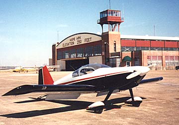
Wednesday blessed us with winds out of the southwest as we blasted homeward. The GPS's indicated 190 mph over the ground as we flew north of Dallas and on to Hope, AR. Topping the tanks meant we were good to go for the final leg, and 2.2 hours later we were back home at Decatur, AL. What a trip! After the planes had received loving pats on the cowls and were tucked into their hangars, we stood around somewhat stunned at what we had accomplished in less than five days. Many aviators have had similar experiences, but this trip warped our perspective of relative distances as we now realized we were only two days from anywhere in the lower forty-eight states! Trips such as Oshkosh and Sun-N-Fun which formerly seemed like major hauls were now recognized as quick little hops. And the most remarkable facet of the whole adventure was that we had been safely transported across half the country in little crafts that had been birthed in our backyards. The awesome potential of our planes was now sinking in, and it only whetted our appetite for more journeys in the future. See you around,
Back to Page One of Westward Ho!
|
Lessons Learned 1) The RV is a real traveling machine! The D. J. Lauritsen seats are comfortable for three hours at a time, and if you and your partner can fit into a 172 or Warrior, you will be fine in the RV-6. The chart clip I installed on the right side of the panel worked great at holding the map so both of us could glance at it. 2) The Lowrance 100 is a great little GPS. Not a single glitch was observed in 25 flight hours, and this was with the unit mounted to the panel and running the internal antenna. We were able to hug the convoluted restricted airspace around the Grand Canyon by just watching our progress on the moving map. 3) As noted, attention needs to be given to baggage loading. The RV-8 was not nearly as sensitive to loading as the -6 since the front compartment could be used to offset loading in the rear. The RV-8 also has a higher gross wt rating than the RV-6. From now on, I will give a passenger a small bag and tell them to fill it.....and that is it! If it means leaving some stuff on the ramp at home, so be it. Obviously, the pilot also needs to think in terms of how much "plane" stuff really needs to be carried. By the way, hauling heavy tie-downs was not a problem. Robin and I both had a set of the incredibly light weight titanium Ti-Downs from Randy Simpson. 4) As western pilots already know, density altitude issues are for real! I was amazed at how long the takeoff rolls became as we ascended to the higher elevations. And this was February! I had to slightly modify my takeoff technique because at home, the RV-6 practically jumps off the ground with little effort from the pilot. But it was necessary at the higher elevations to "pin" the mains to the ground as the plane was given ample time to accelerate. Prior to learning this lesson, I actually had the plane to skip into the air, then plop right back down onto the runway until it was finally ready to fly. Flopping and reflopping back down in various attitudes at a groundspeed in excess of 80 mph is not good! I can hear the western pilots laughing, but remember, we flatlanders seldom experience density altitudes above 3000'. 5) WAC charts are very useful, especially when used in conjunction with a moving map GPS. Since a larger area is covered, less map folding is required and only 2-3 WAC's are necessary for a major trip. 6) A trip such as this is great for sorting out various power and mixture settings. This was the first time I had a chance to spend hours at a time playing with throttle settings in 399SB. What I found was somewhat surprising. My plane has the 150hp E2D engine, Bob's has the 160hp D1A, and Robin's RV-8 has the firebreathing IO-360 with constant speed prop. Yep, the big 360 got the best fuel burn at the speeds we were flying. At 6500' my engine is limited by the prop to slightly over 2500 rpm. While the engine is probably happy at that rpm, I am happier at around 2400-2450 rpm. This yields MAP's in the 24" range which should be in the ballpark of 75% power. On the third leg of our first day, I got a little behind the other planes and pushed the throttle all the way forward at 7500'. Fuel burn for the leg was over 9.5 gal/hr. I realize I was probably too timid about leaning as aggressively as I should, but it seems that the extra fuel burn resulted in practically no increase in speed. From then on I decided to keep the throttle at least 1/4" from full and this seemed to keep the throttle out of the enricher circuit. Rpm consistently was in the 2450 range, EGT could be leaned about 90 degrees, fuel burn was about 8.5 gal/hr, TAS was close to 170 mph, and most important, I was happy. By the way, Robin practically had fuel running out the tanks since at this speed the big 360 was burning fuel at around 6.5 gal/hr! 7) The Navaid wing leveler is a nice component for a long trip. I still haven't gotten the thing to track properly, but even so, it only requires an occasional tweak to keep the track close to where you want it. I have found, however, that I can fly the plane smoother in light turbulence than the Navaid. The RV-6 likes to wag its tail in turbulence, and the Navaid works too hard at trying the keep the wings level. A steady hand on the control stick results in a more comfortable ride. It is nice, however, to be able to flip on the wing leveler when you need to fold a chart or do some photography.
Tell Sam what you think about this article and trip.....
The photos were created by David Ausley and Sam Buchanan. |
|