ANCIENT COORDINATES
9/18/99
Dear Graham Hancock,
I'm so glad you responded and were actually curious. This is the detail of what I have worked out so far. A table and diagrams are attached. There are a lot of details in this theory which match your theory. When the poles are moved and ancient mysterious sites are marked, spots at equal intervals form parallel lines. One is the ancient equator and the other is probably the ancient tropic of Cancer line. With these in place, one feels the need to mark the ancient tropic of Capricorn, but I must confess, I know of no real sites along it. After I first wrote to you, I worked on it some more and actually wrote a program which would convert from one coordinate system to the other. Its been a long time since Ive done that kind of math so it was a long, painful process getting my rusty gears going again. After a huge effort and advice from a skeptical friend who felt the need to lecture me on the silliness of my thoughts, I finally wrote a little program which is so simple it works in Microsoft Excel. I found coordinates for the Great Pyramid and for the city of Cuzco and used them to find the poles exactly. At first, I was sure there would be 12 equally spaced spots like the zodiac but there are 10. I also thought there might be 20 spots instead due to some other likely sites, but after I got the program to give me exact longitudes and latitudes, my idea about 20 faded.
Some sites work out within a few miles, others are off by a couple hundred miles. If the ancients were barely able to work out the sites, then the poor accuracy would be believable. Unfortunately, that would make it harder to find them today. If the ancients were extremely accurate in marking the sites, then the poor accuracy may be due to us not finding exactly the right centers but only the neighboring constructions. After all, if the people were guarding sacred sites, it would be reasonable to expect to find a whole country built up around them. What marks the sites? Well, I liked your idea of navels of the world. You said that Easter Island and Cuzco were marked with the bathtub type stones. The one at Easter Island may look crude because the real one is now under water. The sarcophagus in the Great Pyramid looks a lot like the one in Cuzco. I dont know of any other sites with a bathtub type marker, do you? I do know of one other site that was called a navel of the world, but it doesnt fit this grid and it is marked by a beehive style stone. It is near Athens, where the oracle of Delphi lived. When are possible times the world could have changed its poles, I assume along with major worldwide catastrophes? The Maya say 3100 BC, about 5100 years ago. If the problem was cyclical, as the Maya imply, then the previous time would have been about 8200 BC. The next time would have been about 13,300 BC, but you had a little detail in your book that said they thought only 4000 years, so 12,200 BC. For now, lets ignore the year 2012 problem. If you assume these sites were from an ancient time, before at least 3100 BC, when the poles were different, then the dating of the sites using the star alignments on the ground (Orion at Giza and Draco at Angkor), would be totally wrong. Sorry, but the stars would have shifted and the precession would have been different and the 10,500 BC date would be dead wrong. If the sites were restored much more recently, as they seem to be, and religious cults still had the ancient knowledge, then the 10,500 BC date may be correct. After all, it is the approximate time a lot of mammals went extinct.
What happened in 3100 BC? This date is significant all around the world. It also falls within the time of writing. You would think there would be a detailed written account of what happened at this time, but there doesnt seem to be. The Maya said it marked the new age, maybe also the birth of Venus. The Egyptian king lists started then. There is an Incan story about a flood then but it may be rather fictional (Chronicle of Akakor, by Karl Brugger). Archeologists discovered evidence of flooding in Sumeria at that time. In India, 3100 BC marked the hypothetical grand conjunction of all the planets. The only other ancient calendar starts I know of are 3760 BC (Jewish and Sumerian) and 5500 BC (Greek church in Russia and also the approximate date of the Black Sea flooding). Were the calendars actually created at those times and used to mark events? The Jews dont seem to use year dates in the Bible. Mayan dates on stones dont predate about 300 BC, do they? The Sumerians didnt put a date on the Gilgamesh story. Personally, I think the ancient sites I marked show 10,000 BC and a different set should mark between 8000 and 3000 BC. Im having trouble being confident about marking the 3100 BC sites. Maybe they were never marked, or at least not completely around the whole world because at that time we could no longer do such a global project. If more could be learned about that time, then it might be easier to understand the even older time. Something must be written somewhere.
Now, some calendar talk which is needed to date the ancient sites. Did you notice that 5100 years, a Mayan cycle, is equal to about 2 zodiac ages if you use 10 zodiac ages instead of 12? Two times the 2160 years in the 12 system is equal to only 4520 years, but two times 26000/10 or 2600 years in a 10 system is equal to 5200 years, or a Mayan age. One zodiac (base 10) period before now would be about 550 BC, when calendars were very active, including the zodiac. The age of Aries started in 2220 BC which seems fine. The age of Taurus started in 4380 BC, the 3100 date falling within the age. What if a recalibration was needed then to keep the constellations lined up with the vernal equinox? Maybe Taurus really started further back, say 8200-2600= 5600 BC, now that date looks more familiar. Then Gemini would have started 8200 BC instead of 6540 BC. The Atlantis story is full of twins. Rome was founded by twins but seems to be the wrong time. Cancer? I dont know any crab stories. Maybe that age didnt exist before a recalibration and it was used only as a filler. Then there is Leo, which points to the time of the Sphinx.
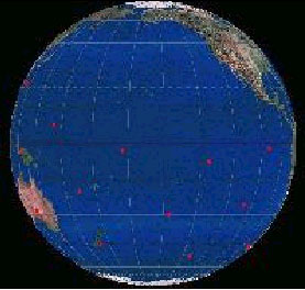
Now, some tidbits before I talk about the actual sites. With the poles moved, Antarctica is much farther north and warmer. Much of the United States would be close to the pole and too cold for people to bother to live there. Charles Hapgood placed the poles right where I do, but dates them to 18,000 BC. Mammoth remains are found very far north in Siberia with buttercups in their stomachs, but they can be found much further south in America. Also, the ancient Tropic of Cancer sites cut the ancient Equator site connecting lines in the golden proportion ratio (0.618 or 22.25 degrees of the 36 degrees for each segment).
OK, here are my calculations. I found exact coordinates for the Great Pyramid on the net and got the other coordinates by estimating from a little atlas I have at home. The calculations are only as good as the data I put in. If you know of more exact coordinates for some of these sites, I will gladly fine tune the program. Other sites which carry some mystique, but didnt work were Mexico City, Stonehenge, Jerusalem, Athens, Lhasa, Tiahuanaco, Malta, any Mayan sites, and any European megalithic sites besides Carnac. Maybe some of these sites belong to a newer grid dating between 8000 BC and 3000 BC, or maybe it just was the building style of the area, marking nothing in particular. See the table for the calculated coordinates. The diagrams are great, thanks to my younger son, the computer software wizard. My older son is the computer hardware wizard. I cant get the lines to appear straight in these diagrams because they are based on different poles. I can assure you that when you get a cheap globe you will see these are actually very straight. I got my globe for about $10 at the local K-mart.
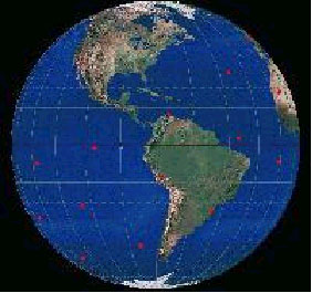
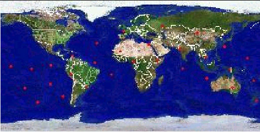
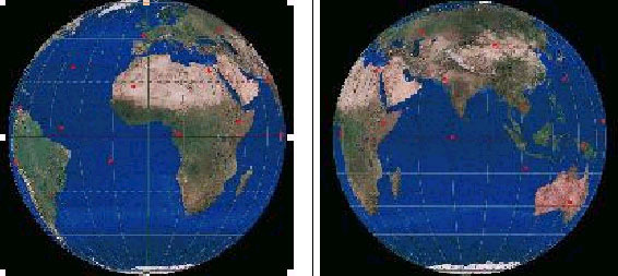
It seems reasonable to start by following the equator beginning at the Great Pyramid. It is certainly megalithic and an entire civilization is built up around it. There is a small problem, east at that time would have been close to east today, but off by one or two degrees. I was under the impression that the Sphinx faces exactly due east. Does it? Next is India. There is nothing notable there today. It is near the Indus River, but not at it. Angkor Wat is near the calculated site, but is off by more than 200 miles. The actual site is on the Cambodia / Viet Nam border deep in the jungle. It is the kind of place that only Indiana Jones type people would dare to venture. Since it is probably deep in the jungle, it has a good chance of still being there. Next is Irian Jaya in Indonesia. This is another deep jungle place for an Indiana Jones type. Next comes three Pacific Ocean sites for a Dirk Pitt type (from the Clive Cussler adventure books) to explore. Detailed maps of the islands and the water depths around them are needed. Dont forget, the time we are talking about had a much lower sea level. First is a site near an island called Malekula which is supposed to have megalithic structures but is well guarded by a native tribe that some people thought were cannibals. Secret sites like that are definitely worthy of an investigation. The next site I know nothing about except that it is very wet. The third Pacific site is Easter Island. My calculations show it to be off by more than 30 miles, so it may be under water. Cuzco, Peru is a site you already investigated and is surrounded with very mysterious megalithic walls. This place oozes with mystery. Lake Titicaca is too far over, but may date from the same time. A whole civilization built up around this site too. Next is a site in the Atlantic. In your book, you implied there are little islands, more like rocks, near there, but no map of mine shows them. This could be Atlantis. Only a scuba diver could find out. Finally, the tenth site falls in the Sahara Desert deep in the middle of nowhere. During the time we are talking about, this area was more habitable. Now blowing sand moves around constantly and can be piled 100s of feet over the real ground level. They use satellite photography to find riverbeds under the Sahara sand. A whole city could be buried there and detectable using space technology. Just imagine how well preserved everything would be under that sand!
The Tropic of Cancer line is about 23 degrees above the equator, like today. That is a little too coincidental for my taste, but oh well. First well start with Carnac, France. Europe is full of megalithic sites, but only this one looks like that. This site is in a class of its own. The real site with the marker may fall a few miles off shore on the continental shelf. The parallel lines of stones go for miles in a north east direction, just like my line! There was a time I thought the sacred center stone at Chartres might be involved, but my calculations show that it is probably too far away. Next is a site north of the Caspian Sea. This could be the Garden of Eden, but who knows. It is near the Black Sea, the Tigris and Euphrates Rivers start in Turkey. The Bible mentions a river that flows around Cush, usually assumed to be Ethiopia, but there is also a mountain range near there called the Hindu Kush with the Indus River near it. The fourth river in the Bible is unclear. Where were the Aryans from? Next is the very southern part of Mongolia, just north of China. This is probably Shangri-La. A book called The Atlas of Mysterious Places edited by Jennifer Westwood mentions three stories about immortal people living in total harmony. The locations implied in the stories from India, Russia, and China point to a place they drew a circle on. It is where my dot falls! The next site is near Okinawa. It is not exactly on the Yonaguni site, but further east over some tall under water mountains. Maybe there are a lot of pyramids under that water, perhaps a whole civilization. Next is Nan Madol. The site is not exact, but even you implied the natives think it is under water. Next comes three more Pacific sites that Dirk Pitt would love to explore. The next site is off the Venezuelan coast. I have heard that there are a lot of underwater sites in that area, but I cant find out any details. However, it is a Caribbean site with lots of promise. Finally, the tenth site is over the Mid Atlantic Ridge. Maybe this is Atlantis, but I know of no islands there. Maybe there is a tall under water mountain there.
The Tropic of Capricorn sites are not well defined, but I drew them on the globe anyway. One spot falls on Ethiopia which is a country surrounded with ancient mystique. Another spot falls on the Maldive Islands and you implied in your book that there were rumors about underwater pyramids there. Another site is near Ayers Rock in Australia, but not at it. Another site is near New Zealand. Finally, I saw pictures of a megalithic site in southern Brazil near one of my spots, but I dont know the exact location.
Happy hunting and dont wait too long to tell me what you think! I want to hear about new stuff!
Carrie Kozikowski
| Site | Latitude | Longitude |
| Used for calibration | ||
| Great Pyramid | 29.98 N | 31.13 E |
| Cuzco | 13.53 S | 71.95 W |
| Easter Island | 27.08 S | 109.33 W |
| Carnac | 47.6 N | 3.0 W |
| Poles | Latitude | Longitude |
| North | 59.59 N | 138.0 W |
| South | 59.59 S | 42 E |
| Ancient Equator | Latitude | Longitude |
| Great Pyramid, Giza, Cairo, Egypt | 29.96 N | 31.13 E |
| Great Indian Desert, Rajasthan, India | 26.91 N | 72.14 E |
| Cambodia / Viet Nam border, not Angkor but near | 13.47 N | 107.91 E |
| Irian Jaya mountains, Indonesia | 4.34 S | 139.43 E |
| Very Southern Vanuatu, Malekula | 20.82 S | 172.38 E |
| In the Pacific, near Tubuai Islands | 29.96 S | 148.87 W |
| Easter Island | 26.91 S | 107.86 W |
| Cuzco, Peru, not Tiahanaco | 13.47 S | 72.09 W |
| Atlantic, near Amazon | 4.34 N | 40.57 W |
| Eastern Mauritania, Sahara Desert | 20.82 N | 7.62 W |
| Ancient Tropic of Cancer | Latitude | Longitude |
| Carnac, France | 47.60 N | 3.00 W |
| Samara, Russia | 53.56 N | 49.32 E |
| Southern Mongolia | 43.90 N | 98.28 E |
| Southern Japan, near Okinawa | 26.61 N | 133.18 E |
| Nan Madol, Caroline Islands | 9.29 N | 162.86 E |
| Phoenix Islands | 3.22 S | 166.52 W |
| Marquesas Islands | 7.02 S | 133.62 W |
| Pacific | 0.64 S | 101.18 W |
| Aruba, Venezuela | 13.56 N | 71.14 W |
| Mid Atlantic Ridge | 31.38 N | 40.88 W |